PC 170 100% Pure New Zealand

PC 170 1

A glass Kiwi by Flame Daisy, a Nelson artist

Adrift on Tasman Bay! Despite the Captain wanting the boats to stay together as far as possible, the lifeboat, cutter and the Captain’s Gig carrying the 26 passengers and 24 crew drifted independently away from The Queen Bee, stranded fast on the sand and taking on water. There were few oars, no sails and little provisions. (See PC 169)

The lifeboat carrying a Mrs Gibbs, some of her 8 children, and other passengers and crew, slipped to the east of Separation Point and south into the estuary of the Awaroa River, where it beached a day and a half later.

PC 170 2

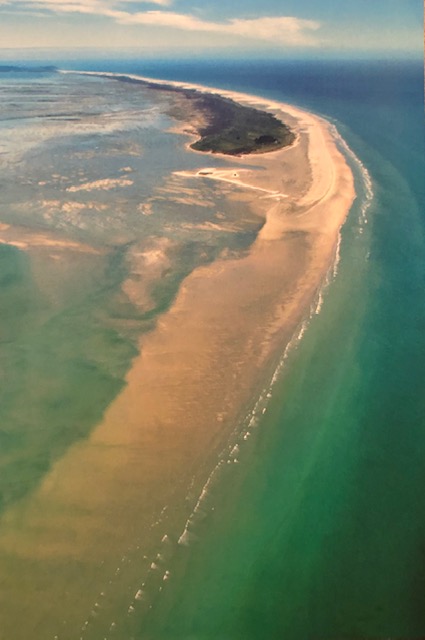
Awaroa River entrance

PC 170 3

Today Awaroa is part of the Able Tasman National Park, an area of immense beauty and wilderness, attracting walkers and bird watchers, those wanting quiet and those wanting a chance to unwind. Abel Tasman, a Dutch explorer, had charted both North and South Island in 1642. Today his name also lives on in the Tasman Sea which separates Australia and New Zealand and in Tasmania, originally named Van Diemen’s Land.

There are no roads through the park and access is on foot or by ‘sea-shuttle’, out of Kaiteriteri. (I had a real problem pronouncing this little resort, as initially I took the first four letters …. and then had nowhere to go! As soon as I thought ‘Kai…..’ it was easy as in Kai … teri…teri. Funny life huh!) The trip up to Awaroa took some 80 minutes; we stopped to let people on and off, we detoured to look at seals and rock formations ……

PC 170 4

… and the colour of the cool water just made you feel good to be alive. We stayed in the Awaroa Lodge, tucked in the bush a few hundred metres from the beach.

PC 170 5

East of Awaroa across Tasman Bay, D’Urville Island forms the western edge of the Marlborough Sounds, an area of some 4000 km² of islands, sounds and peninsulas. The island was named after the French explorer Cesar Dumont D’Urville, who had sailed through in his corvette Astrolabe in 1827. Whilst the Captain’s gig beached on its northern tip, 35 kms down on its southern tip, the cutter carrying Eva and her two sisters ran into Te Puna Bay.

PC 170 6

Te Puna Bay

Here they stayed until the following day when they rowed up the treacherous channel between the mainland and D’Urville Island, through the narrows of French Pass, where the sea rushes through at around 8 knots in a series of violent eddies and whirlpools, and around the corner into Elmslie Bay.

PC 170 7

The Narrows of French Pass

PC 170 8

D’Urville Island and the narrows of French Pass

PC 170 9

Elmslie Bay

The first settler to put down roots on this remote headland had been an Arthur Elmslie in 1857. Twenty years later the overloaded, leaking cutter carrying twenty two survivors from the Queen Bee arrived, after a traumatic 55 hour passage, the men, women, children and one ten day old baby, often up to their waists in water and continually baling to keep the boat afloat.

PC 170 10

We walked on that pebbly beach  …….. and I imagined the sheer relief as the crunch of the keel of the cutter  carrying Eva and the others announced their deliverance. Hours later the ship Aurora, out of Nelson, anchored offshore, the survivors taken on board and eventually, after awaiting a change in the tide, the ship returned to a huge welcome in the town.

PC 170 11

The second pier (circa 1950) at Elmslie Bay replaced the 1907 one

I am in awe of nature and the landscape and out on the road to and from French Pass, I can’t not stop for another photograph, another look, another ‘soak-up-the-scenery’. Looking east from the road towards Hallam Cove and the little community of Cissy Bay, the vegetation is draped across the hills like gathered velvet, or like the facial skin folds of a Pug puppy.

PC 170 12

It’s breathtaking, it’s 100% pure New Zealand …… and around every bend there was another photo opportunity! Celina looked resigned! It’s 60 kilometres from the start of Rai Valley to this isolated community and the road took four years to build, scraped from the hillside by the bulldozer of the Blake Brothers who won contract after contract to finally complete it in 1957.

PC 170 13

The road snaking along the hills

Eva’s traumatic experience drew us to French Pass; without that we probably would never have gone (Note 1). Fifty people live here, but the nearest provisions are effectively in Nelson, 90 minutes away. We were self-catering, so we had to take everything we needed for three nights ….. but we didn’t count on having no electricity for 20 hours …… and that meant no water, as in rural communities water is pumped; for while we were there in December last year South Island suffered some torrential rain and long-lasting thunderstorms. Further south in Timaru someone recorded 250 mm of rain in 24 hours!

PC 170 14

 Thunderstorms over D’Urville Island

We had left Collingwood, right up on the north-west corner of South Island, to start our Farewell Spit Tour.

PC 170 15

The Collingwood Old Courthouse Café – a good place for lunch

We had stayed at ‘Adrift at Golden Bay’, near Takaka (another interesting pronunciation. My instinct was to accent the ‘k’s …. as in TaKaKa, but was corrected by the girl behind the bar at The Mussel Inn who said the locals pronounce it Taaaakaka.). Run by a lovely chap originally from Bolton, Lancashire, it was a wonderful oasis of calm with its own private beach.

PC 170 16

The view from our chalet across the immaculate gardens to the sea.

Then around the crescent of Tasman Bay, through Nelson, and out to French Pass, along that long dirt road. Everywhere we went we encountered friendly and curious Kiwis, interested in what we were doing. If it hadn’t been for that old yellowing front page of The Nelson Evening Mail from 11th August 1877, we might never have known about the Queen Bee and never have gone, but by God we are glad we did. One hundred percent pure New Zealand you might say?

Richard 23rd January 2020

PS Before flying home, from Nelson we flew up to Auckland for the weekend and caught up with distant relatives (the connection is the great great grandfather!!) who have become good friends.

PPS When thinking about this trip, I went to Google Maps, zoomed in on Nelson on South Island, found a travel agent (worldtravellers.co.nz) and sent them an email. If anyone knew about the local area, they would. The whole trip, including international flights and our Singapore stay, was organised by email through them. When we were on the ground, having a local contact was invaluable. Highly recommended!!

Note 1 In 2015 we drove a similar journey to Eagle in Alaska. Seventy miles down the Taylor Highway, Eagle on the Yukon River is another isolated community at the end of a long dirt road! George Nation, whom Eva had married in Dunedin in 1884, managed a gold mining operation there in 1901 (See PC 44 & 45).

PC 169 Shifting Sands and Feathers


Flying back to the UK from Wellington, New Zealand, having participated in the first gathering in Auckland of my great great grandfather Henry Nation’s descendants, I happened to glance out of the aircraft’s starboard window ……….. and saw Farewell Spit, on the northern tip of South Island. It was March 2011 and by then I understood its significance in my life, for it was there in August 1877 that a 17 year old girl, Eva Constance Fosbery who became my great grandmother, was shipwrecked and survived – for without her survival I would not be here!

PC 169 1

In the summer of last year I hatched a plot to go and stand as near as possible to where the ship was stranded and also visit where Eva and two of her sisters came ashore 3 days later. (PCs 152 & 154 refer).

PC 169 2

The Queen Bee

There are few spits of sand that grow as much as Farewell Spit. It is estimated that in the 150 years since a lighthouse was first constructed the Spit has lengthened by 5 kilometres; it’s now 32 long, from Cape Farewell at its western end to its tip. It has also widened considerably; at low water the lateral distance from north to south is over 10 kilometres! Access by the public is limited to the first 4; the Farewell Spit Tour Company runs regulated visits out to the lighthouse at low water, another 23.

PC 169 3

 Notice the little green blob South East of the light. We went beyond that!

The lighthouse’s 1870 wooden structure was built on the sand-blasted end of the Spit, with no vegetation and no shelter. The staff that managed it brought soil from nearby fields, planted trees and bushes ….. and in over one hundred years transformed the site into a little sheltered oasis.

PC 169 4

Farewell Spit Lighthouse today

The steel-lattice tower replaced the wooden structure in 1897. From an oil-burning lamp to large bulb to a small 50w tungsten halogen bulb with magnifying lenses, it’s now completely automatic and stands over four kilometres from the end of the Spit at high tide. Its ‘light characteristics’ are white with red sectors flashing once every 15 seconds. Of course during the stranding of the Queen Bee, one of the passengers was heard to ask the captain if the red light showing on the lighthouse was a warning. “It’s nothing you should worry about, Mrs Gibbs; leave the sailing of the boat to us professionals.” Talk about famous last words: an hour later the Queen Bee grounded!

PC 169 5

Looking east down the spit

Beyond this, nature holds sway …… some two kilometres past the lighthouse is a huge Australasian Gannet colony. Gannets usually nest on rocky cliff faces but here 60 breeding pairs arrived in 1982 and now the colony has some 9000 birds nesting on a shell bank; they stay for about four months.

PC 169 6

Conservation authorities limit the numbers of tourists able to visit this colony so we were lucky ……. as I could imagine …….. back in August 1877 ……… that it was somewhere just here the 726 ton Queen Bee grounded on the sand and juddered to a halt. Despite the efforts of the crew to get her off, she stuck fast and as the tide receded her predicament became far too obvious. Large waves crashed onto the deck, the strain on her timbers showed as water started leaking into her hold and by breakfast time the captain decided to abandon ship. One lifeboat came ashore at Awaroa Bay, on the western coast of Tasman Bay, a cutter beached 70 miles across Tasman Bay on the south coast of D’Urville Island three days later and the Captain’s gig ended up on the northern tip of the same island. The ship was uninsured and at auction the wreck sold for £335 and its 30 tons of cargo for £385. This ‘cargo’ included the passengers’ personal possessions, which they then had to buy back from those who had bought the wreck!!

PC 169 7

This the little green blob on the second photo, with the lighthouse barely visible to the west.

Today there is nothing to see …… but maybe, just maybe, ten feet, twenty feet under the sand where we stood lay the skeletal ribs of that great ship.

PC 169 8

It got a little soggy underfoot and I saw our guide Charles Mersmans, from the Farewell Spit Tour Company, looking at his watch, checking the tide times. Time to go! As when the land is so flat, the tide can rush in at an alarming rate.

PC 169 9

The Gannets don’t care about wrecks and such like, their sole purpose to replicate their species; every year the numbers increase and the Spit is one of those places so important on the global migration routes of seabirds. I am no ornithologist, although I can tell the difference between a white and black swan, the latter abundant here from their native Australia. And of course I know there is no difference between a shag and a cormorant but the first has rather smutty connotations, the latter a rather regal ring, so prefer the second name. But our guide Charles was hugely knowledgeable about our feathered friends. Did you know, for instance, that the red bill of the Oyster Catcher will change shape within weeks depending on what food is available?

PC 169 10

Red-billed Oyster Catchers. Apparently they stand on one leg to conserve energy.

Sand is deposited on the spit from the northerly-going current up the west coast of South Island, mainly from the shrinking Franz Josef glacier ….. so it’s grey, granite sand. And it shifts! We saw the ribs of an old coal trading ship that came ashore in the late 1800s; our guide hadn’t seen it for six months and had a story about its sinking concerning debts and insurance and such like.

PC 169 11

We climbed a sand dune and from the top saw the extent of the spit, as far as our eyes could see; and then we ran down its steep side like children. And we were lucky with the weather; normally the wind blows above 25kph, picking up the fine sand and reducing visibility. On the day of our visit you could see for miles.

PC 169 12

We saw a whale blowing on the north side of the spit, apparently unusual at this time of year. And on the south side of the Spit, in Golden Bay, pilot whales and dolphins are frequently caught by the rapid-changing tides and strand. Last year about 300 died in January and February, despite huge efforts by the local population to keep them hydrated until the tide changed. It’s a hugely upsetting occurrence. We saw seals close up ….. which they found unsettling and generally headed as quick as their flippers and tail could power them across the sand to the sea.

PC 169 13


PC 169 14

Looking East across Golden Bay

When we think of shipwrecks, we probably think of rocks and cliffs and raging pounding seas. In this case the ship grounded on a sandbar. (Note 1) …….. and that gave us an opportunity to connect geographically and emotionally with Eva. We will connect with her again in PC 170. Farewell Spit is a very special place.

PC 169 15

Richard 9th January 2020

Note 1: When sailing in shallow estuarial waters, where the underwater contours shift and change, one has to be careful! I remember many years ago being on a 32 ft yacht when it grounded on the sandy seabed off Ryde on the Isle of Wight. Fortunately there wasn’t a great deal of wind, but we had to wait until the tide started to rise again before we could sail off; God’s way of saying: “Time for tea & toast?”